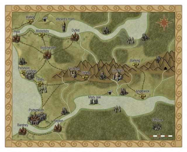
Here’s a regional map I did with Torchbearer in mind. It’s got all the recommended places from page 115.
Elflands: Elfhome, Misty Isle
Dwarven Halls: Fel Norn, Fel Krad
Religious Bastion: Lichfield
Bustling Metropolis: Portsmouth
Wizard’s Tower: Wizard’s Horn
Remote Village: Barking, Stirling, Anglewick
Busy Crossroads: Pent, Brotchester
Mountains, Rivers, Roads, Coast, Forest
Edit: It’s smaller than the original image I put on Photobucket for some reason. Message me if you want a larger copy, I guess.
I like this. What did you use to make it?
The larger version is here, by the way, though you need to click on it twice to display it at full size.
Campaign Cartographer 3, with Annual #6.
Sweet! Also, I’m interested to hear the story behind Lichfield. Is it like those cool bone churches they have in places?
I’m on an immurement kick right now, so maybe the stronghold at Lichfield is made of great big blocks of stone, and behind each block is immured the body of a martyr who gave his or her life to sanctify the stronghold. They can be felt everywhere within its walls, and they are present in the dreams of any who sleep within it. Some say that the grandmaster can call the spirits up as a garrison if Lichfield were ever to be breached by an enemy.
Each stone bears the graven name of the martyr who lies behind it, so the effect is of a stronghold built of tombstones.